Japan, Koizumi Sokki
Koizumi Sokki iRTK5x GNSS receiver

Product made in Japan
Manufacturer : Koizumi Sokki
Model : iRTK5x
Characteristics

iRTK5x is the latest GNSS receiver equipped with next-generation GNSS engine, Hi-Fix technology and IMU that enables calibration-free tilt survey.
With its innovative magnesium alloy body, Linex3.2.0 operating system and waterproof HD OLED touch panel display, it provides the most advanced RTK surveying solution.
Features
- First-class GNSS survey instrument registered with the Geospatial Information Authority of Japan
- GNSS receiver compatible with all satellite positioning systems
・ 336-channel positioning
・ NGS-certified GNSS antenna
・ Supports GPS, GLONASS, GALILEO, BDS, SBAS, QZSS
・ Reduces multipath with unique antenna technology - Equipped with Hi-Fix technology
RTK positioning accuracy is maintained even when communication is temporarily interrupted and correction information is interrupted. It enables continuous observation in the field with poor communication environment. - Pseudo-dynamic RTK
Even if the FIX solution is lost in a forest, etc., and the float solution is degraded, the previous positioning solution can be used to obtain FIX-equivalent accuracy. - Web management system
You can access the GNSS receiver from a web browser such as a smartphone or PC via WiFi connection. You can make various settings and check the positioning status in real time. - HD OLED touch panel screen
Equipped with a 1.3 inch 240×240 pixel touch screen with waterproof performance. You can quickly check the settings and status on the receiver side. - Robust design conforming to US Department of Defense standards
・Dust and water resistance IP67
・Shock and vibration resistance MIL-STD-810G, 514.6
・Salt damage resistance MIL-STD-810G, 509.4 96 hours
・Free fall MIL-STD-810G, 2m above concrete - Large-capacity lithium-ion battery

- ・ 6,800mAh lithium-ion battery
・ Smart battery with remaining power indicator
・ RTK (mobile station) can be used for 10 hours - Connect seamlessly to network RTK
In addition to standard RTK positioning using fixed and mobile stations, it also supports network RTK. - Can be connected to other companies’ apps (Kaisoku Navi, Field Terrace, etc.)
Using the Android app (Hi-Survey), it is possible to transfer GNSS positioning coordinates to other companies’ apps.
Adopting an IMU to achieve stable tilt surveying
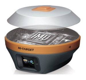
Equipped with an IMU that enables calibration-free tilt surveying. It is possible to detect the inclination direction with high accuracy even in a magnetic environment that was difficult with the conventional direction sensor method.
Efficiency can be improved by approximately 20% compared to leveling using a vial.
It achieves an accuracy of about 2-3 cm within a tilt angle of 30 degrees.

